• Home
  • Routes
  • Act
  • About
  • Contact
  • FAQ
  • Supporters
  • Help
  • GeoArtMap
  • Home
  • Routes
  • Act
  • About
  • Contact
  • FAQ
  • Supporters
  • Help
  • GeoArtMap
  Wheels of Change
  • Home
  • Routes
  • Act
  • About
  • Contact
  • FAQ
  • Supporters
  • Help
  • GeoArtMap
Picture

Wheels of Change

Routes
Extended through July 25 & 26, 2020
#WOCBLM

Extended through July 25 & 26, 2020 

​Because of an amazing increase in registrations Friday-Sunday and also the weekend's intense heat, we are extending to give everyone time to put their mark on the map. 

We will report miles, minutes and headcount on both the BLM MESSAGE routes and also on additional miles off the route but with the #WOCBLM hashtag in support of the message.

REMINDER:  For your miles to show up on the heat map, you must follow the 5 steps to register and include #WOCBLM in the title on your Strava activity. All activities welcome. 

Route options

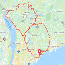
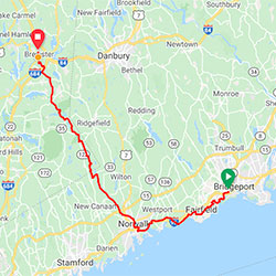
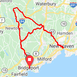
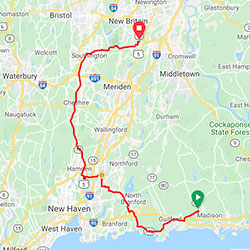
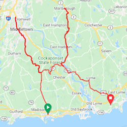
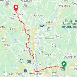
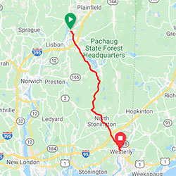
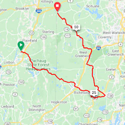
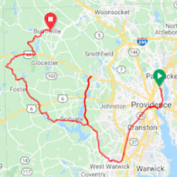
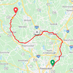
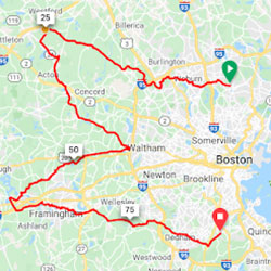
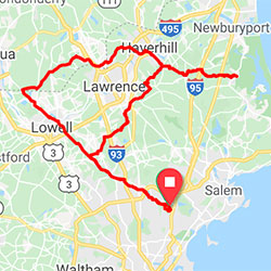
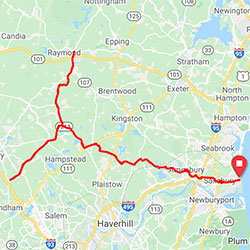
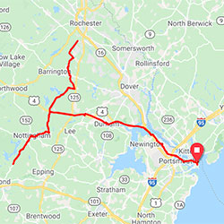
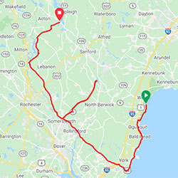
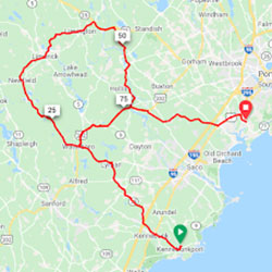
From NYC to ME – cyclists, runners, walkers, tricycles, etc.... all are encouraged to join. Walk a block or ride 200 miles! Each letter is a separate downloadable route. There are routes in NY, CT, RI, NH and ME!  Everyone can ride in their home turf. Have fun and be safe.  Be kind to others!

​IMPORTANT:
Routes marked ***** do not begin/end in the same place.
Routes marked "ferry" have a ferry crossing - please check RideWithGps route for schedule.
Routes marked with "MTA" are MTA accessible.
Routes marked with "NOTE" have extra route details - listed below all the route choices.
Some routes may contain small sections of dirt road - these dirt sections can be ridden by ANY kind of bike. No special bike is required. 


ROUTE MODIFICATIONS: You can make your own choices about route modifications.  We did our best but locals always know better. As long as it stays near the main line of the route it will be fine.  This is your ride. We are just the instigators for what we hope will be a massive show of good will and intention to change.
SAFETY: There is nothing more important than safety. If you come upon a section of route which feels unsafe, we urge you to go back and find a way around. There may be "day of obstacles we aren't aware of. 
VIRTUAL PARTICIPATION OPTION
​ If you would feel more comfortable participating "virtually", you can do so by riding the routes using a smart trainer and the indoor cycling app ROUVY.
Find out more...
Remember, your activity only counts if you do these important steps:
  1. REGISTER - as a participant or event volunteer to receive information and help us manage the event. 
  2. JOIN -  Strava if you are not already a member. Sign up for free
  3. JOIN - the  the free ​Wheels of Change Strava Club
  4. ACTIVATE - the WOC app. After you join the WOC Strava Club, CONNECT your Strava account to Wheels of Change. Click here to authorize us to access your public activities and contribute to our Geo Art map and event statistics. (We respect your privacy - we will only upload publicly available data. You can deauthorize our access at any time using the Settings/My Apps feature on the Strava website.)
  5. Add #WOCBLM to your Strava activity title after your ride/walk/run is done
Picture
Route #1 -- B
103 miles, 5700 vertical feet,  
southeastern NY, southwestern CT

Picture
Route #2 -- L    *****
45 miles, 2800 vertical feet, 
 
southeastern NY, southwestern CT

Picture
Route #3 -- A
​104 miles, 6500 vertical feet, 
 
​southern CT

Picture
Route #4 -- C    ***** 
50 miles, 2,000 vertical feet,
​southern CT

Picture
Route #5 -- K    ***** ferry, NOTE
104 miles, 7500 vertical feet  
​
southern CT

Picture
Route #6 -- L    *****
​40 miles, 2700 vertical feet 

southeastern CT


Picture
Route #7 -- I    *****
​22 miles, 1300 vertical feet  southeastern CT, southwestern RI

Picture
Route #8 -- V    *****
​58 miles, 2600 vertical feet 
​southeastern CT, 
southwestern RI

Picture
Route #9 -- E    *****
63 miles, 3800 vertical feet
​western RI

Picture
Route #10 -- S    *****
​47 miles, 1800 vertical feet southeastern MA

Picture
Route #11 -- M    ***** MTA
​84 miles, 3300 vertical feet
​metro Boston, MA

Picture
Route #12 -- A
104 miles, 3400 vertical feet, 
 
​northeastern MA, southern NH

Picture
Route #13 -- T
83 miles, 2400 vertical feet, 

eastern MA, southeastern NH

Picture
Route #14 -- T
83 miles, 3800 vertical feet, 
 
southeastern NH

Picture
Route #15 -- E    *****
73 miles, 4500 vertical feet, 
 
​southeastern ME

Picture
Route #16 -- R    *****
92 miles, 3600 vertical feet, 
​
southeastern ME

ROUTE NOTES:

Route K
  • WORKAROUND for dirt section of Old County Road, South of Route 81.  At intersection of 81 and Hidden Lake go 81 North (Killingworth Road) for about 1/2 mile and then right on Parker Hill Road which turns into County Road in another half mile and is paved again. You are back on the route.
  • CAUTION  Gulf Road turns into hard pack gravel at the bottom of a steep hill. It’s rideable but be cautious coming down the hill because you may not be able to see where the gravel starts.  It is a gorgeous dirt road along the Salmon River. Worth riding.  And at the end of it, before continuing on the course, you might cross the street and ride up to the beautifully restored covered bridge. It’s worth a stop.
  • ALTERNATIVE to FERRY  The Ferry is really one of the highlights of the trip and worth the 1-20 minute wait.  But if you are running low on time or juice, you save three miles  by riding down to 151 Ferry Road, Lyme, CT 06371 on the East side of the River and then continue the route.  Instead of taking a right on Boardman Road off 151 South, Continue onto CT-82 East for 1.3 mi., Turn right onto State Hwy 431 South for 2.4 mile, then continue on to CT-148 W for .1 mile and then onto Ferry Road to continue the Route.

Download route info Excel file

Please download an Excel file for additional details regarding routes:
woc-routes-20200701.xlsx
File Size: 23 kb
File Type: xlsx
Download File

How to join Strava & have your miles count

  1. Visit Strava or download the Strava App
  2. Create an account
  3. Join the Wheels of Change club
  4. Record your ride/walk/run activity
  5. How to "write" a letter or a portion of a letter on Strava:
  • Start your Strava activity when you are at the beginning of one of the Letter routes (or the portion of a Letter you will traverse). 
  • Stop your Strava activity when you are done with all (or a portion of) the Letter route.
  • When you save the activity include #WOCBLM in the name.
  • If you have to go off route, pause your  Strava activity until you are back on route. 
  • Do not include anything but the Letter in your activity. For example, if you ride to and from the letter, make those separate activities. Only the Letter itself should be included in the activity for this Wheels of Change event.

How to ride the routes "virtually"

Picture
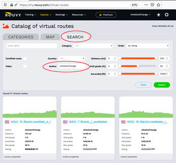
The Wheels of Change routes are available in the indoor cycling app ROUVY.

Go to rouvy.com
  • sign up for ROUVY and create an account
  • go to the ROUVY catalog of  virtual routes
  • click on the "Search" tab
  • enter "wheelsofchange" in the Author search field and click the green "search" button
  • find the WOC route you want to ride, click on the route link
  • make your route choice a "favorite" by clicking on the green "add to my favorites" button (you must be logged in to do this). This will make it much easier to select the route you want to ride once you have launched the ROUVY app.
  • Download the ROUVY app for your device

​Once you have launched the ROUVY app
  • click the "Change" button to choose your route
  • that will take you to the Search page where you can select your route from "My Favorite". You may have to scroll right to see the Favorite icon.
  • Enjoy your ride!
Picture

Wheels of Change Strava Club latest activities

WHEELS OF CHANGE
#WOCBLM
Press
Contact